
Mapa topográfico Landershofen
Mapa interactivo
Haga clic en el mapa para ver la altitud.
Acerca de este mapa
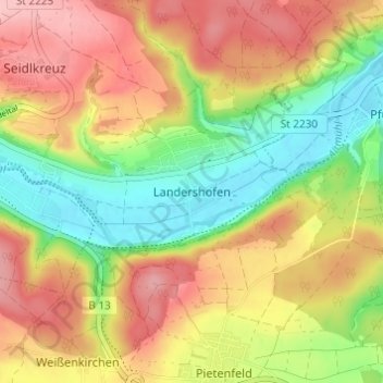
Nombre: Mapa topográfico Landershofen, altitud, relieve.
Altitud media: 456 m
Altitud mínima: 381 m
Altitud máxima: 529 m
Otros mapas topográficos
Haga clic en un mapa para ver su topografía, su altitud y su relieve.
Hofmühle
Deutschland > Bayern > Landkreis Eichstätt > Eichstätt > Rebdorf
Hofmühle, Rebdorf, Eichstätt, Landkreis Eichstätt, Bayern, 85072, Deutschland
Altitud media: 475 m
Rebdorf
Deutschland > Bayern > Landkreis Eichstätt > Eichstätt
Rebdorf, Eichstätt, Landkreis Eichstätt, Bayern, 85072, Deutschland
Altitud media: 472 m