
Mapa topográfico Paravur
Mapa interactivo
Haga clic en el mapa para ver la altitud.
Acerca de este mapa
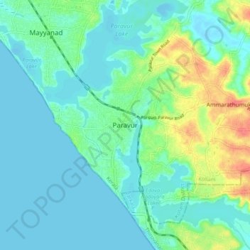
Nombre: Mapa topográfico Paravur, altitud, relieve.
Lugar: Paravur, Kollam, Kollam District, Kerala, 691301, India (8.76989 76.63153 8.84989 76.71153)
Altitud media: 14 m
Altitud mínima: -5 m
Altitud máxima: 60 m
Paravur is located at 8.78 N 76 E. It has an average elevation of 10 metres (32 feet). Paravur, 21 kilometers from the Kollam, is a narrow skirt of land stretching in between the backwaters and the sea. There is an elevation of 6 metres above sea level, extending to 16 metres on the inland. Ithikkara river is flowing through paravur. Nedungolam in paravur is now famous for mangrove forest.
Otros mapas topográficos
Haga clic en un mapa para ver su topografía, su altitud y su relieve.
Kizhakkekallada
Kizhakkekallada, Kollam, Kollam District, Kerala, 691502, India
Altitud media: 10 m
Chirakkara
Chirakkara, Kollam, Kollam District, Kerala, 691578, India
Altitud media: 36 m
Thrikkovilvattom
India > Kerala > Kollam > Thrikkovilvattom
Thrikkovilvattom, Kollam, Kerala, 691577, India
Altitud media: 23 m