
Mapa topográfico Madison County
Mapa interactivo
Haga clic en el mapa para ver la altitud.
Acerca de este mapa
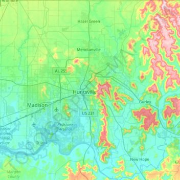
Nombre: Mapa topográfico Madison County, altitud, relieve.
Lugar: Madison County, Alabama, United States (34.47666 -86.79009 34.99207 -86.25830)
Altitud media: 245 m
Altitud mínima: 166 m
Altitud máxima: 565 m
The topography in the southern and eastern portions of the county is dominated by the dissected remnants of the Cumberland Plateau, such as Keel Mountain, Monte Sano Mountain and Green Mountain. The northern and western portions of the county are flatter.