
Mapa topográfico Orange County
Mapa interactivo
Haga clic en el mapa para ver la altitud.
Acerca de este mapa
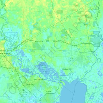
Nombre: Mapa topográfico Orange County, altitud, relieve.
Lugar: Orange County, Texas, United States (29.93988 -94.11890 30.24266 -93.68843)
Altitud media: 4 m
Altitud mínima: -6 m
Altitud máxima: 17 m
The geography of Orange County varies relatively little, with an elevation that reaches 33 ft (10 m) above sea level at very few points within the county. Orange County is very flat, and its soil is quite sandy, as could be expected in a county along the Gulf of Mexico. (Sandy soil is also common in southern Louisiana, Mississippi, and Alabama, and in western and southern Florida.) Saltwater marshes occur in much of the southeastern part of Orange County that borders the Sabine River. The Piney Woods are in the northern part of the county.
Otros mapas topográficos
Haga clic en un mapa para ver su topografía, su altitud y su relieve.
Bridge City
United States > Texas > Orange County > Bridge City
Bridge City, Orange County, Texas, 77611, United States
Altitud media: 3 m