
Mapa topográfico Peerless Lake
Mapa interactivo
Haga clic en el mapa para ver la altitud.
Acerca de este mapa
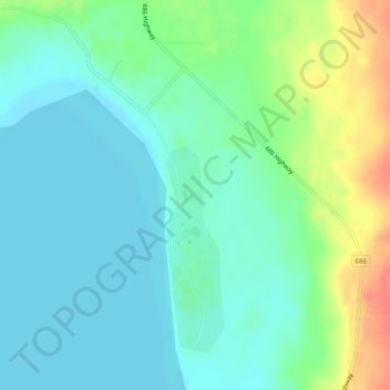
Nombre: Mapa topográfico Peerless Lake, altitud, relieve.
Altitud media: 703 m
Altitud mínima: 687 m
Altitud máxima: 745 m
Peerless Lake is an unincorporated community in northern Alberta, Canada. It is located on the northeastern shore of Peerless Lake, approximately 70 kilometres (43 mi) northeast of Red Earth Creek, and has an elevation of 695 metres (2,280 ft).
Otros mapas topográficos
Haga clic en un mapa para ver su topografía, su altitud y su relieve.
Calling Lake
Canada > Alberta > Municipal District of Opportunity > Calling Lake
Calling Lake, Municipal District of Opportunity, Alberta, T0G 0K0, Canada
Altitud media: 609 m
Red Earth Creek
Canada > Alberta > Municipal District of Opportunity > Red Earth Creek
Red Earth Creek, Municipal District of Opportunity, Alberta, T0G 1X0, Canada
Altitud media: 549 m
Wabasca-Desmarais
Canada > Alberta > Municipal District of Opportunity > Wabasca-Desmarais
Wabasca-Desmarais, Municipal District of Opportunity, Alberta, T0G 2K0, Canada
Altitud media: 556 m