
Haz una donación
Mapa topográfico Himachal Pradesh
Haga clic en el mapa para ver la altitud.
Haz una donación
Himachal Pradesh
Due to extreme variation in elevation, great variation occurs in the climatic conditions of Himachal Pradesh. The climate varies from hot and humid subtropical in the southern tracts to, with more elevation, cold, alpine, and glacial in the northern and eastern mountain ranges. The state's winter capital, Dharamsala receives very heavy rainfall, while areas like Lahaul and Spiti are cold and almost rainless. Broadly, Himachal experiences three seasons: summer, winter, and rainy season. Summer lasts from mid-April until the end of June and most parts become very hot (except in the alpine zone which experiences a mild summer) with the average temperature ranging from 28 to 32 °C (82 to 90 °F). Winter lasts from late November until mid-March. Snowfall is common in alpine tracts. Pollution is affecting the climate of almost all the states of India. Due to steps taken by governments to prevent pollution, Himachal Pradesh has become the first smoke-free state in India which means cooking in the entire state is free of traditional chulhas.
Haz una donación
Acerca de este mapa
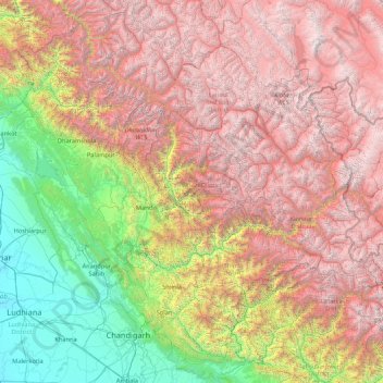
Nombre: Mapa topográfico Himachal Pradesh, altitud, relieve.
Lugar: Himachal Pradesh, India (30.37717 75.59401 33.25567 79.01238)
Altitud media: 2 869 m
Altitud mínima: 232 m
Altitud máxima: 6 687 m
Haz una donación
Otros mapas topográficos
Haga clic en un mapa para ver su topografía, su altitud y su relieve.
Dehradun
India > Uttarakhand > Dehradun
The city of Dehradun mainly lies in Doon Valley and is at a varying height from 410 m (1,350 ft) in Clement Town to above 700 m (2,300 ft) at Malsi which is 15 km (9.3 mi) from the city. However, the average elevation is 450 m (1,480 ft) above sea level. Malsi is the starting point of Lesser Himalayan Range…
Altitud media: 904 m
Maharashtra
Maharashtra is the third largest state by area in India. The Western Ghats better known as Sahyadri, are a hilly range running parallel to the coast, at an average elevation of 1,200 metres (4,000 ft). Kalsubai, a peak in the Sahyadris, near Nashik city is the highest elevated point in Maharashtra. To the west…
Altitud media: 478 m
Haz una donación
Prayagraj
India > Uttar Pradesh > Prayagraj
Prayagraj's elevation is over 90 m (295 ft) above sea level. The old part of the city, at the south of Prayagraj Junction railway station, consists of neighbourhoods like Chowk, Johnstongunj, Dariyabad, Khuldabad and many more. In the north of the Railway Station, the new city consists of neighbourhoods like…
Altitud media: 91 m
Visakhapatnam
India > Andhra Pradesh > Visakhapatnam (Urban)
The city is situated between the Eastern Ghats and the Bay of Bengal. The city coordinates lies between 17.7041 N and 83.2977 E. The city's area is 682 km2. The average elevation is 45 metres. Visakhpatnam is situated in Coastal Andhra Region.
Altitud media: 35 m
Haz una donación
Udaipur
India > Rajasthan > Girwa Tehsil
Udaipur is located at 24°31′30″N 73°40′38″E / 24.525049°N 73.677116°E / 24.525049; 73.677116. The city covers an area of 64 km2 (25 sq mi) and lies at an altitude of 598.00 m (1,962 ft) above sea level. It is located in the southern region of Rajasthan, near the Gujarat border. The city…
Altitud media: 656 m
Haz una donación
Bhopal
India > Madhya Pradesh > Huzur Tahsil
Bhopal has an average elevation of 500 metres (1401 ft) and is located in the central part of India, just north of the upper limit of the Vindhya mountain ranges. Located on the Malwa plateau, it is higher than the north Indian plains and the land rises towards the Vindhya Range to the south. The city has…
Altitud media: 498 m
Kolkata
Spread roughly north–south along the east bank of the Hooghly River, Kolkata sits within the lower Ganges Delta of eastern India approximately 75 km (47 mi) west of the international border with Bangladesh; the city's elevation is 1.5–9 m (5–30 ft). Much of the city was originally a wetland that was…
Altitud media: 5 m
Haz una donación
Solan
India > Himachal Pradesh > Solan
Solan is a city in the Indian state of Himachal Pradesh and the district headquarters of Solan district. It is located 45.5 kilometres (28 mi) south of the state capital, Shimla. Solan has an average elevation of 1,550 metres (5,090 ft). The city is situated between Chandigarh (joint capital of Punjab and…
Altitud media: 1 312 m
Western Ghats
The range starts near south of the Tapti river and runs approximately 1,600 km (990 mi) through the states of Gujarat, Maharashtra, Karnataka, Goa, Kerala and Tamil Nadu ending at Marunthuvazh Malai near the southern tip of India. These hills cover 160,000 km2 (62,000 sq mi) and form the catchment area for…
Altitud media: 2 225 m
Haz una donación
Mangaluru
India > Karnataka > Mangaluru taluk
Mangalore is also the administrative headquarters of the Dakshina Kannada district; it is a commercial, industrial, educational, healthcare, and startup hub. The city's international airport is the second-largest and second-busiest airport in Karnataka. Mangalore City Corporation is responsible for the civic…
Altitud media: 25 m
Haz una donación
Kannur
India > Kerala > Kannur > Kannur
Kannur has an elevation of 1.02 metres or 3.3 feet along the coast of the Laccadive Sea, with a sandy coastal area. The city has an 8 kilometres (5.0 mi)-long seashore and a 3 kilometres (1.9 mi)-long beach at Payyambalam. Kannur is located north of Kozhikode, south of Kasargod and Mangalore, west of the…
Altitud media: 13 m
Surat
India > Gujarat > Katargam Taluka > Surat
Surat is a port city situated on the banks of the Tapi river. Damming of the Tapi caused the original port facilities to close; the nearest port is now in the Magadalla and Hazira area of Surat Metropolitan Region.It has famous beach called 'Dumas Beach' located in Hazira. The city is located at 21°10′N…
Altitud media: 11 m
Haz una donación
Dasuya
India > Punjab > Dasua Tahsil
Dasuya is located in Hoshiarpur district of Punjab state in India. at 31°49′N 75°40′E / 31.82°N 75.66°E / 31.82; 75.66. It has an average elevation of 239 metres (784 ft) from sea level.
Altitud media: 254 m
Haz una donación
Mysuru
India > Karnataka > Mysuru taluk
Mysore (/maɪˈsɔːr/ (listen)), officially Mysuru ([ˈmaɪˈsuːɾu] (listen)), is a city in the southern part of the state of Karnataka, India. Mysore city is geographically located between 12° 18′ 26″ north latitude and 76° 38′ 59″ east longitude. It is located at an altitude of 770 m (2,530 ft)…
Altitud media: 727 m
Haz una donación
Haz una donación
Haz una donación
Haz una donación
Haz una donación
Lucknow
India > Uttar Pradesh > Lucknow
The city stands at an elevation of approximately 123 metres (404 ft) above sea level. Lucknow city had an area of 402 km2 (155 square miles) till December 2019, when 88 villages were added to the municipal limits and the area increased to 631 km2 (244 square miles). Bounded on the east by Barabanki, on the…
Altitud media: 120 m
Haz una donación
Dwarka
India > Gujarat > Okhamandal Taluka
Considered a holy city, Dwarka is well known for its temples and as a pilgrimage centre for Hindus. The Dwarakadhisa Temple, also called Jagat Mandir, located in the heart of Dwarka, is a Vaishnava temple. It was built by Raja Jagat Singh Rathore, hence it is called Jagat Mandir. The temple, facing west, is at…
Altitud media: 3 m
Thiruvananthapuram
India > Kerala > Thiruvananthapuram
Thiruvananthapuram is built on seven hills by the seashore and is at 8°30′N 76°54′E / 8.5°N 76.9°E / 8.5; 76.9 on the west coast, near the southern tip of mainland India. The city is on the west coast of India and is bounded by the Laccadive Sea to its west and the Western Ghats to its east.…
Altitud media: 33 m
Lucknow
India > Uttar Pradesh > Lucknow
Lucknow stands at an elevation of approximately 123 metres (404 ft) above sea level. The city had an area of 402 km2 (155 square miles) until December 2019, when 88 villages were added to the municipal limits and the area increased to 631 km2 (244 square miles). Bounded on the east by Barabanki, on the west by…
Altitud media: 120 m
Haz una donación
Siliguri
India > West Bengal > Matigara block
Siliguri located at the foothills of the eastern Himalayas at a location of 26°43′N 88°26′E / 26.71°N 88.43°E / 26.71; 88.43. This city is spread over an area of 260 km2 within the Siliguri Corridor, also known as the Chicken's neck. The city is surrounded by dense forests towards north and…
Altitud media: 121 m
Jamshedpur
India > Jharkhand > Golmuri-Cum-Jugsalai
Jamshedpur is situated in the southern end of the state of Jharkhand and is bordered by the states of Odisha and West Bengal. The average elevation of the city is 135 metres while the range is from 129 m to 151 m. Total geographical area of Jamshedpur is 224 km square. Jamshedpur is primarily located in a…
Altitud media: 195 m
Haz una donación
Haz una donación
Kovilpatti
India > Tamil Nadu > Kovilpatti
Kovilpatti is located at 9°10′N 77°52′E / 9.17°N 77.87°E / 9.17; 77.87. It has an average elevation of 101 metres (334 feet).
Altitud media: 97 m
Haz una donación
Haz una donación
Gariaband
India > Chhattisgarh > Bindranavagarh(Gariyaband) Tahsil
Gariaband is Loceted on 20°38′N 82°03′E / 20.63°N 82.05°E / 20.63; 82.05. Gariaband has an average elevation of 318 metres (1043 ft).
Altitud media: 346 m
Jhalawar
India > Rajasthan > Jhalrapatan Tehsil
Jhalawar is located at 24°36′N 76°09′E / 24.6°N 76.15°E / 24.6; 76.15. It has an average elevation of 312 metres (1023 feet).
Altitud media: 319 m
Haz una donación
Chakdaha
India > West Bengal > Chakdaha
Chakdaha is a prominent urban local body in the district of Nadia, one of the southern districts of West Bengal. Chakdaha's location is 23°05′N 88°31′E / 23.08°N 88.52°E / 23.08; 88.52. It has an average elevation of 11 meters (36 feet) and is 62 km north of the state capital, Kolkata. It is…
Altitud media: 10 m
Haz una donación
Chang La
Chang La is a high mountain pass in Ladakh at an elevation of 5,391.3024 m (17,688.000 ft) in the Ladakh Range between Leh and the Shyok River valley. The Chang La, on Leh to Pangong Lake road, lies on the Leh-Karu-Sakti-Zingral-Chang La-Durbuk-Tangtse-Pangong Lake motorable road. Karu, which lies on…
Altitud media: 5 464 m
Jabalpur
India > Madhya Pradesh > Jabalpur Tahsil > Jabalpur
The Narmada river bringing in freshwater from the Vindyachal Ranges has developed Jabalpur district into an agrarian economy. The land of the Narmada basin with its fertile alluvial soil gives good yields of sorghum, wheat, rice, and millet in the villages around Jabalpur. Important among commercial crops are…
Altitud media: 413 m
Ernakulam
India > Kerala > Kanayannur
The Ernakulam District is situated in Central Kerala in India. Ernakulam is located at 9°59′N 76°17′E / 9.98°N 76.28°E / 9.98; 76.28. It has an average elevation of 4 m (13 ft).
Altitud media: 6 m
Haz una donación
Chennai
Chennai is located on the south–eastern coast of India in the north–eastern part of Tamil Nadu on a flat coastal plain known as the Eastern Coastal Plains. Its average elevation is around 6.7 metres (22 ft), and its highest point is 60 m (200 ft). Chennai is 2,184 kilometres (1,357 mi) south of Delhi,…
Altitud media: 7 m
Haz una donación
Western Ghats
The range starts near south of the Tapti river and runs approximately 1,600 km (990 mi) through the states of Gujarat, Maharashtra, Karnataka, Goa, Kerala and Tamil Nadu ending at Marunthuvazh Malai, Swamithope near the southern tip of India. These hills cover 160,000 km2 (62,000 sq mi) and form the catchment…
Altitud media: 2 225 m
Haz una donación
Dharamshala
India > Himachal Pradesh > Dharamshala
Dharamshala has an average elevation of 1,457 m (4,780 ft), covering an area of almost 8.51 km2 (3.29 sq mi). Dharamsala is located in the Kangra Valley, in the shadow of the Dhauladhar mountains.
Altitud media: 1 781 m
Haz una donación