
Haz una donación
Mapa topográfico Brooks Range
Haga clic en el mapa para ver la altitud.
Haz una donación
Acerca de este mapa
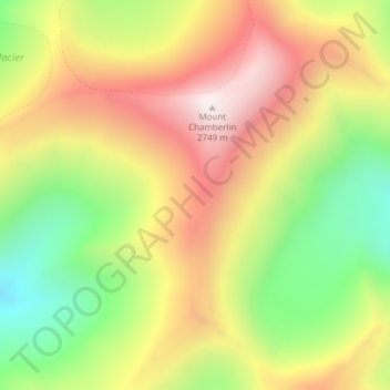
Nombre: Mapa topográfico Brooks Range, altitud, relieve.
Lugar: Brooks Range, North Slope Borough, Alaska, United States (69.27135 -144.91375 69.27145 -144.91365)
Altitud media: 2 115 m
Altitud mínima: 1 578 m
Altitud máxima: 2 720 m
Haz una donación
Otros mapas topográficos
Haga clic en un mapa para ver su topografía, su altitud y su relieve.
Utqiaġvik
United States > Alaska > North Slope Borough
Despite the extreme northern location, temperatures at Utqiagvik are moderated by the surrounding topography. The Arctic Ocean is on three sides, and flat tundra stretches some 200 mi (320 km) to the south. No wind barriers or protected valleys exist where dense cold air can settle or form temperature…
Altitud media: 4 m
Toolik Lake
United States > Alaska > North Slope Borough
Tussock tundra dominates the terrain surrounding the lake. Other plant communities in the area include wet sedge tundra, as well drier heath tundra found at higher elevations. Low growing shrubs are abundant, including birches and willows. Trees are not present. Since surveys began, there has been a 19 percent…
Altitud media: 731 m
Haz una donación
Toolik Lake
United States > Alaska > North Slope Borough
Tussock tundra dominates the terrain surrounding the lake. Other plant communities in the area include wet sedge tundra, as well drier heath tundra found at higher elevations. Low growing shrubs are abundant, including birches and willows. Trees are not present. Since surveys began, there has been a 19 percent…
Altitud media: 731 m
Utqiaġvik
United States > Alaska > North Slope Borough
Despite the extreme northern location, temperatures at Utqiagvik are moderated by the surrounding topography. The Arctic Ocean is on three sides, and flat tundra stretches some 200 mi (320 km) to the south. No wind barriers or protected valleys exist where dense cold air can settle or form temperature…
Altitud media: 4 m