
Gracias por apoyar a este sitio ❤️
Haz una donación
Haz una donación
Mapa topográfico El Paso
Haga clic en el mapa para ver la altitud.
Gracias por apoyar a este sitio ❤️
Haz una donación
Haz una donación
Acerca de este mapa
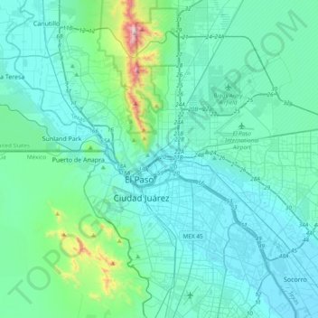
Nombre: Mapa topográfico El Paso, altitud, relieve.
Lugar: El Paso, El Paso County, Texas, 79903, United States (31.61542 -106.62463 31.93542 -106.30463)
Altitud media: 1 232 m
Altitud mínima: 1 111 m
Altitud máxima: 2 164 m
Gracias por apoyar a este sitio ❤️
Haz una donación
Haz una donación
Otros mapas topográficos
Haga clic en un mapa para ver su topografía, su altitud y su relieve.
Franklin Mountains State Park
United States > Texas > El Paso County > El Paso
Franklin Mountains State Park is a Texas state park in El Paso, Texas, that protects the Franklin Mountains. Park headquarters are located at an elevation of 5,426 feet (1,654 m) with the highest peak, North Franklin Mountain, reaching 7,192 feet (2,192 m). It is one of the largest urban parks in the nation…
Altitud media: 1 293 m