
Mapa topográfico Zaragoza
Mapa interactivo
Haga clic en el mapa para ver la altitud.
Acerca de este mapa
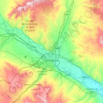
Nombre: Mapa topográfico Zaragoza, altitud, relieve.
Lugar: Zaragoza, Aragon, Spain (41.45166 -1.17373 41.93149 -0.68039)
Altitud media: 361 m
Altitud mínima: 160 m
Altitud máxima: 752 m
On 1 January 2021 the population of the municipality of Zaragoza was 675,301, (the fifth most populated in Spain) on a land area of 973.78 square kilometres (375.98 square miles). The population of the metropolitan area was estimated in 2006 at 783,763 inhabitants. The municipality is home to more than 50 percent of the Aragonese population. The city lies at an elevation of about 208 metres (682 feet) above sea level.
Otros mapas topográficos
Haga clic en un mapa para ver su topografía, su altitud y su relieve.