
Mapa topográfico Lac de Gaube
Mapa interactivo
Haga clic en el mapa para ver la altitud.
Acerca de este mapa
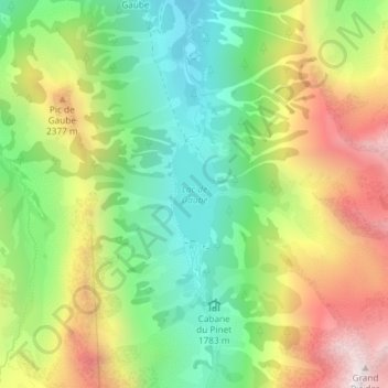
Nombre: Mapa topográfico Lac de Gaube, altitud, relieve.
Altitud media: 2 079 m
Altitud mínima: 1 642 m
Altitud máxima: 2 689 m
The lake is situated in an altitude of 1725 m, an egg-shaped form stretching itself along a north–south axis in the valley of Gaube. This steep-sided valley is located at the foot of the Vignemale (3298M). The lake is surrounded by the peak Mayouret (2688 m) to the east, the big Peak of the Paloumères (2720 m) to the southeast, and the peak of Gaube (2377 m) to the northwest.
Otros mapas topográficos
Haga clic en un mapa para ver su topografía, su altitud y su relieve.
Vue sur Cascades et Pont d'Espagne
France > Occitania > Hautes Pyrenees > Cauterets
Vue sur Cascades et Pont d'Espagne, Pont d'Espagne, Cauterets, Argelès-Gazost, Hautes Pyrenees, Occitania, Metropolitan France, 65110, France
Altitud media: 1 827 m