
Mapa topográfico Dutywa
Mapa interactivo
Haga clic en el mapa para ver la altitud.
Acerca de este mapa
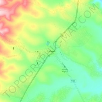
Nombre: Mapa topográfico Dutywa, altitud, relieve.
Altitud media: 833 m
Altitud mínima: 730 m
Altitud máxima: 1 006 m
Otros mapas topográficos
Haga clic en un mapa para ver su topografía, su altitud y su relieve.
Mbashe
South Africa > Eastern Cape > Amathole District Municipality > Mbhashe Local Municipality
Mbashe, Mbhashe Ward 21, Mbhashe Local Municipality, Amathole District Municipality, Eastern Cape, South Africa
Altitud media: 66 m
Ngxutyana River
South Africa > Eastern Cape > Amathole District Municipality > Mbhashe Local Municipality
Ngxutyana River, Mbhashe Local Municipality, Amathole District Municipality, Eastern Cape, South Africa
Altitud media: 88 m
Ngqatyana
South Africa > Eastern Cape > Amathole District Municipality > Mbhashe Local Municipality
Ngqatyana, Mbhashe Local Municipality, Amathole District Municipality, Eastern Cape, South Africa
Altitud media: 268 m