
Mapa topográfico Swain County
Mapa interactivo
Haga clic en el mapa para ver la altitud.
Acerca de este mapa
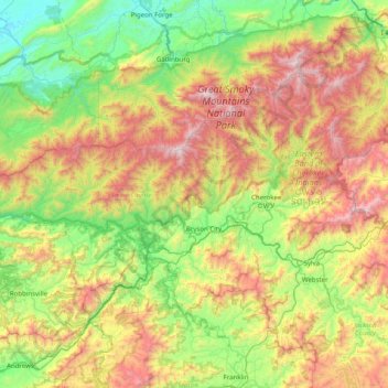
Nombre: Mapa topográfico Swain County, altitud, relieve.
Lugar: Swain County, North Carolina, United States (35.27911 -83.95339 35.69589 -83.15583)
Altitud media: 893 m
Altitud mínima: 267 m
Altitud máxima: 2 014 m
According to the U.S. Census Bureau, Swain county has a total area of 541 square miles (1,400 km2), of which 528 square miles (1,370 km2) is land and 13 square miles (34 km2) (2.3%) is water. The county is located in the far western part of North Carolina in the Great Smoky Mountains and contains a larger proportion of the Great Smoky Mountains National Park than any other county in North Carolina or Tennessee. The highest point in the county is Clingmans Dome, elevation 6,643 feet, located on the NC/TN border. Clingman's is the third highest peak in North Carolina, and a walkable observation tower is located on its summit. The highest mountain in North Carolina and in the United States east of the Mississippi River is Mt. Mitchell, 6,684 feet, located northeast of Asheville.
Otros mapas topográficos
Haga clic en un mapa para ver su topografía, su altitud y su relieve.
Bryson City
United States > North Carolina > Swain County
Bryson City, Swain County, North Carolina, United States
Altitud media: 592 m