
Mapa topográfico Gāro Hills
Mapa interactivo
Haga clic en el mapa para ver la altitud.
Acerca de este mapa
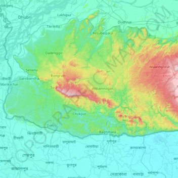
Nombre: Mapa topográfico Gāro Hills, altitud, relieve.
Lugar: Gāro Hills, East Garo Hills, Meghalaya, India (24.86000 89.86000 26.14000 91.14000)
Altitud media: 192 m
Altitud mínima: 0 m
Altitud máxima: 1 492 m
Otros mapas topográficos
Haga clic en un mapa para ver su topografía, su altitud y su relieve.
Khasi Hills
India > Meghalaya > Mawshynrut
Khasi Hills, Mawshynrut, West Khasi Hills District, Meghalaya, India
Altitud media: 349 m
Khliehriat
Khliehriat, East Jaintia Hills District, Meghalaya, India
Altitud media: 717 m
Sonapani Waterfall Cliff
India > Meghalaya > Mylliem > Shillong
Sonapani Waterfall Cliff, Lower Mawprem, Shillong, Mylliem, East Khasi Hills District, Meghalaya, 793001, India
Altitud media: 1 402 m
Sohsarat
India > Meghalaya > Shella Bholaganj
Sohsarat, Shella Bholaganj, East Khasi Hills, Meghalaya, India
Altitud media: 562 m
Jymmang ne Mawshamok
India > Meghalaya > Shella Bholaganj
Jymmang ne Mawshamok, Shella Bholaganj, East Khasi Hills, Meghalaya, 793108, India
Altitud media: 654 m
Cherrapunji (Sohra)
India > Meghalaya > Shella Bholaganj > Cherrapunji (Sohra)
Cherrapunji (Sohra), Shella Bholaganj, East Khasi Hills, Meghalaya, 793108, India
Altitud media: 1 248 m
Nongriat
India > Meghalaya > Shella Bholaganj
Nongriat, Shella Bholaganj, East Khasi Hills, Meghalaya, 793108, India
Altitud media: 706 m
Mawlynnong
Mawlynnong, Pynursla, East Khasi Hills, Meghalaya, India
Altitud media: 425 m
South Garo Hills District
South Garo Hills District, Meghalaya, India
Altitud media: 281 m