
Mapa topográfico Chabahar
Mapa interactivo
Haga clic en el mapa para ver la altitud.
Acerca de este mapa
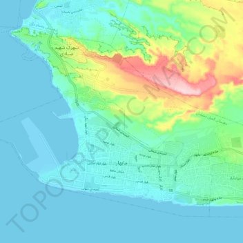
Nombre: Mapa topográfico Chabahar, altitud, relieve.
Altitud media: 48 m
Altitud mínima: -1 m
Altitud máxima: 237 m
Otros mapas topográficos
Haga clic en un mapa para ver su topografía, su altitud y su relieve.
دهستان وشنام دری
Iran > Sistan and Baluchestan Province > Chabahar County
دهستان وشنام دری, Central District, Chabahar County, Sistan and Baluchestan Province, Iran
Altitud media: 62 m
Shahdad Bazar
Iran > Sistan and Baluchestan Province > Chabahar County > دهستان پلان > Shahdad Bazar
Shahdad Bazar, دهستان پلان, بخش پلان, Chabahar County, Sistan and Baluchestan Province, Iran
Altitud media: 32 m