
Mapa topográfico Emmaberg
Mapa interactivo
Haga clic en el mapa para ver la altitud.
Acerca de este mapa
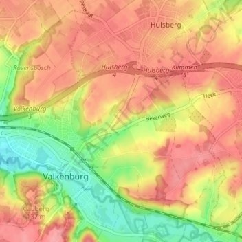
Nombre: Mapa topográfico Emmaberg, altitud, relieve.
Altitud media: 116 m
Altitud mínima: 62 m
Altitud máxima: 151 m
Otros mapas topográficos
Haga clic en un mapa para ver su topografía, su altitud y su relieve.
Valkenburg
Nederland > Limburg > Valkenburg
Valkenburg, Limburg, Nederland, 6301, Nederland
Altitud media: 121 m
Geuldal
Nederland > Limburg > Valkenburg > Houthem
Geuldal, Houthem, Valkenburg, Valkenburg aan de Geul, Limburg, Nederland
Altitud media: 116 m
Sibbe
Nederland > Limburg > Valkenburg
Sibbe, Valkenburg, Valkenburg aan de Geul, Limburg, Nederland, 6301 AR, Nederland
Altitud media: 138 m
Schaelsberg
Nederland > Limburg > Valkenburg
Schaelsberg, Euverem, Valkenburg, Valkenburg aan de Geul, Limburg, Nederland, 6301 PW, Nederland
Altitud media: 105 m
Cauberg
Nederland > Limburg > Valkenburg
Cauberg, Valkenburg, Valkenburg aan de Geul, Limburg, Nederland, 6301 BV, Nederland
Altitud media: 108 m
Sint Gerlach
Nederland > Limburg > Valkenburg > Houthem
Sint Gerlach, Houthem, Valkenburg, Valkenburg aan de Geul, Limburg, Nederland, 6301 JC, Nederland
Altitud media: 107 m
Plenkert
Nederland > Limburg > Valkenburg > Plenkert
Plenkert, Valkenburg, Valkenburg aan de Geul, Limburg, Nederland, 6301GN, Nederland
Altitud media: 112 m