
Mapa topográfico Delrath
Mapa interactivo
Haga clic en el mapa para ver la altitud.
Acerca de este mapa
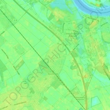
Nombre: Mapa topográfico Delrath, altitud, relieve.
Altitud media: 42 m
Altitud mínima: 32 m
Altitud máxima: 48 m
Otros mapas topográficos
Haga clic en un mapa para ver su topografía, su altitud y su relieve.
Rheinfeld
Deutschland > Nordrhein-Westfalen > Dormagen
Rheinfeld, Dormagen, Rhein-Kreis Neuss, Nordrhein-Westfalen, Deutschland
Altitud media: 41 m
Gohr
Deutschland > Nordrhein-Westfalen > Dormagen > Gohr
Gohr, Dormagen, Rhein-Kreis Neuss, Nordrhein-Westfalen, Deutschland
Altitud media: 51 m
Stürzelberg
Deutschland > Nordrhein-Westfalen > Dormagen
Stürzelberg, Dormagen, Rhein-Kreis Neuss, Nordrhein-Westfalen, Deutschland
Altitud media: 39 m
Straberg
Deutschland > Nordrhein-Westfalen > Dormagen
Straberg, Dormagen, Rhein-Kreis Neuss, Nordrhein-Westfalen, Deutschland
Altitud media: 43 m