
Mapa topográfico Mühleip
Mapa interactivo
Haga clic en el mapa para ver la altitud.
Acerca de este mapa
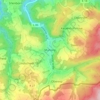
Nombre: Mapa topográfico Mühleip, altitud, relieve.
Altitud media: 225 m
Altitud mínima: 117 m
Altitud máxima: 359 m
Otros mapas topográficos
Haga clic en un mapa para ver su topografía, su altitud y su relieve.
Rankenhohn
Deutschland > Nordrhein-Westfalen > Rhein-Sieg-Kreis > Eitorf
Rankenhohn, Eitorf, Rhein-Sieg-Kreis, Nordrhein-Westfalen, 53809, Deutschland
Altitud media: 227 m
Siebigteroth
Deutschland > Nordrhein-Westfalen > Rhein-Sieg-Kreis > Eitorf > Lascheid
Siebigteroth, Lascheid, Eitorf, Rhein-Sieg-Kreis, Nordrhein-Westfalen, 53783, Deutschland
Altitud media: 173 m
Hüppelröttchen
Deutschland > Nordrhein-Westfalen > Rhein-Sieg-Kreis > Eitorf
Hüppelröttchen, Linkenbach, Eitorf, Rhein-Sieg-Kreis, Nordrhein-Westfalen, 53783, Deutschland
Altitud media: 284 m