
Mapa topográfico Denali National Park and Preserve
Mapa interactivo
Haga clic en el mapa para ver la altitud.
Acerca de este mapa
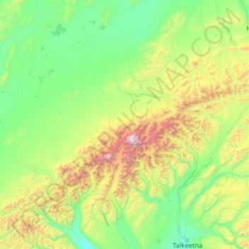
Nombre: Mapa topográfico Denali National Park and Preserve, altitud, relieve.
Altitud media: 777 m
Altitud mínima: 70 m
Altitud máxima: 6 139 m
Denali National Park and Preserve is an American national park and preserve located in Interior Alaska, centered on Denali, the highest mountain in North America. The park and contiguous preserve encompass 6,045,153 acres (9,446 sq mi; 24,464 km2) which is larger than the state of New Hampshire. On December 2, 1980, 2,146,580-acre (3,354 sq mi; 8,687 km2) Denali Wilderness was established within the park. Denali's landscape is a mix of forest at the lowest elevations, including deciduous taiga, with tundra at middle elevations, and glaciers, snow, and bare rock at the highest elevations. The longest glacier is the Kahiltna Glacier. Wintertime activities include dog sledding, cross-country skiing, and snowmobiling. The park received 594,660 recreational visitors in 2018.
Otros mapas topográficos
Haga clic en un mapa para ver su topografía, su altitud y su relieve.
Cape York
United States of America > Alaska
Cape York, Nome, Alaska, United States of America
Altitud media: 75 m
Noatak
United States of America > Alaska > Noatak
Noatak, Northwest Arctic, Alaska, United States of America
Altitud media: 23 m
Johns
United States of America > Alaska
Johns, Unorganized Borough, Alaska, United States of America
Altitud media: 823 m
Mount Pendleton
United States of America > Alaska
Mount Pendleton, Denali, Alaska, United States of America
Altitud media: 1 978 m
Aleutians East
United States of America > Alaska
Aleutians East, Alaska, United States of America
Altitud media: 23 m
North Slope
United States of America > Alaska
North Slope, Alaska, United States of America
Altitud media: 214 m
Northwest Arctic
United States of America > Alaska
Northwest Arctic, Alaska, United States of America
Altitud media: 296 m