
Mapa topográfico Chikkamagaluru
Mapa interactivo
Haga clic en el mapa para ver la altitud.
Acerca de este mapa
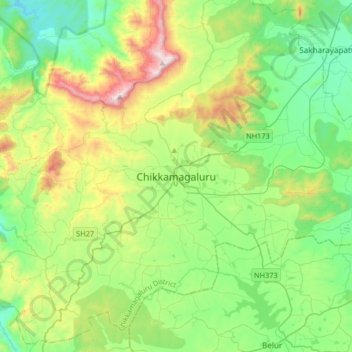
Nombre: Mapa topográfico Chikkamagaluru, altitud, relieve.
Altitud media: 1 052 m
Altitud mínima: 713 m
Altitud máxima: 1 883 m
Chikmagalur is situated in the Malenadu region of Karnataka in the Deccan plateau in the foothills of the Western Ghats. It is situated at an elevation of 1,090 metres (3,580 ft) above mean sea level. The Yagachi River has its source near the town and flows in the south-easterly direction before uniting with the Hemavati river. Chikmagalur generally has a moderate to cool climate. The temperature of the city varies from 11-20 °C during winter to 25-32 °C during summer.
Otros mapas topográficos
Haga clic en un mapa para ver su topografía, su altitud y su relieve.
Mullayyanagiri
India > Karnataka > Chikkamagaluru taluku > Chikkamagaluru
Mullayyanagiri, Chikkamagaluru, Chikkamagaluru taluku, Chikkamagaluru district, Karnataka, 577101, India
Altitud media: 1 548 m