
Haz una donación
Mapa topográfico Mount Tasman
Haga clic en el mapa para ver la altitud.
Haz una donación
Acerca de este mapa
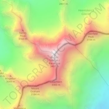
Nombre: Mapa topográfico Mount Tasman, altitud, relieve.
Lugar: Mount Tasman, Westland District, West Coast, New Zealand (-43.56575 170.15714 -43.56565 170.15724)
Altitud media: 2 798 m
Altitud mínima: 2 186 m
Altitud máxima: 3 467 m
Haz una donación
Otros mapas topográficos
Haga clic en un mapa para ver su topografía, su altitud y su relieve.
Franz Josef Glacier
New Zealand > West Coast > Westland District
The névé or snowfield at the head of Franz Josef Glacier is over 2,500 metres (8,200 ft) above sea level and 20 square kilometres (7.7 sq mi) in area. This wide névé, which is over 300 metres (980 ft) deep, feeds large amounts of compacted snow into a steep and narrow valley which drops quickly to very low…
Altitud media: 1 709 m
Haz una donación
Haz una donación
Haz una donación
Fox Glacier
New Zealand > West Coast > Westland District
Chancellor Hut was built in 1930–31 on the southwest face of Chancellor Ridge, now 200 m above the glacier. Planned by mountain guides Alec and Peter Graham in 1929, all the materials had to be packed up Fox Glacier manually in 1930 in the days before helicopter airlifts. It is the oldest remaining mountain…
Altitud media: 1 848 m
Haz una donación
Volta Glacier
New Zealand > West Coast > Westland District
It is split into upper and lower glaciers which are connected by an icefall. The Upper Volta Glacier is between 1,600–2,000 m (5,200–6,600 ft) in altitude and is surrounded by the 3 peaks of Glacier Dome, Pickelhaube and Fastness Peak, while the Lower Volta Glacier sits directly under the North side of…
Altitud media: 1 550 m
Haz una donación
Haz una donación
Haz una donación
Franz Josef Glacier
New Zealand > West Coast > Westland District
The névé or snowfield at the head of Franz Josef Glacier is over 2,500 metres (8,200 ft) above sea level and 20 square kilometres (7.7 sq mi) in area. This wide névé, which is over 300 metres (980 ft) deep, feeds large amounts of compacted snow into a steep and narrow valley which drops quickly to very low…
Altitud media: 1 709 m
Trinity Glacier
New Zealand > West Coast > Westland District > Fiordland Community
Altitud media: 1 391 m
Fox Glacier
New Zealand > West Coast > Westland District
Chancellor Hut was built in 1930–31 on the southwest face of Chancellor Ridge, now 200 m above the glacier. Planned by mountain guides Alec and Peter Graham in 1929, all the materials had to be packed up Fox Glacier manually in 1930 in the days before helicopter airlifts. It is the oldest remaining mountain…
Altitud media: 1 848 m
Haz una donación