
Mapa topográfico Le Villaret
Mapa interactivo
Haga clic en el mapa para ver la altitud.
Acerca de este mapa
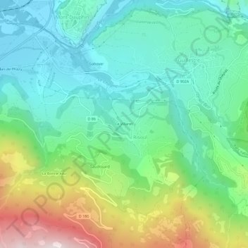
Nombre: Mapa topográfico Le Villaret, altitud, relieve.
Altitud media: 1 171 m
Altitud mínima: 880 m
Altitud máxima: 1 869 m
Otros mapas topográficos
Haga clic en un mapa para ver su topografía, su altitud y su relieve.
Plan de Phazy
France > Provence-Alpes-Côte d'Azur > Hautes-Alpes > Risoul > Le Plan de Phazy
Plan de Phazy, Le Plan de Phazy, Risoul, Briançon, Hautes-Alpes, Provence-Alpes-Côte d'Azur, France métropolitaine, 05600, France
Altitud media: 1 026 m
Le Plan de Phazy
France > Provence-Alpes-Côte d'Azur > Hautes-Alpes > Risoul > Le Plan de Phazy
Le Plan de Phazy, Risoul, Briançon, Hautes-Alpes, Provence-Alpes-Côte d'Azur, France métropolitaine, 05600, France
Altitud media: 1 078 m
La Bonne eau
France > Provence-Alpes-Côte d'Azur > Hautes-Alpes > Risoul > La Bonne eau
La Bonne eau, Risoul, Briançon, Hautes-Alpes, Provence-Alpes-Côte d'Azur, France métropolitaine, 05600, France
Altitud media: 1 391 m
Barbein
France > Provence-Alpes-Côte d'Azur > Hautes-Alpes > Risoul > Barbein
Barbein, Risoul, Briançon, Hautes-Alpes, Provence-Alpes-Côte d'Azur, France métropolitaine, 05600, France
Altitud media: 1 165 m
Gaudissard
France > Provence-Alpes-Côte d'Azur > Hautes-Alpes > Risoul
Gaudissard, Risoul, Briançon, Hautes-Alpes, Provence-Alpes-Côte d'Azur, France métropolitaine, 05600, France
Altitud media: 1 325 m