
Mapa topográfico Clallam County
Mapa interactivo
Haga clic en el mapa para ver la altitud.
Acerca de este mapa
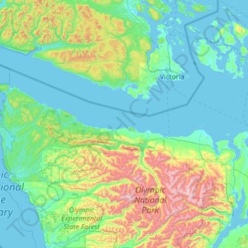
Nombre: Mapa topográfico Clallam County, altitud, relieve.
Lugar: Clallam County, Washington, United States of America (47.86668 -124.83609 48.49344 -122.89716)
Altitud media: 335 m
Altitud mínima: -2 m
Altitud máxima: 2 383 m
Otros mapas topográficos
Haga clic en un mapa para ver su topografía, su altitud y su relieve.
Lake Morton-Berrydale
United States of America > Washington > Lake Morton-Berrydale
Lake Morton-Berrydale, King County, Washington, United States of America
Altitud media: 132 m
Redmond
United States of America > Washington > Redmond
Redmond, King County, Washington, United States of America
Altitud media: 72 m
Lewis County
United States of America > Washington
Lewis County, Washington, United States of America
Altitud media: 558 m
Okanogan County
United States of America > Washington > Okanogan County
Okanogan County, Washington, United States of America
Altitud media: 1 076 m
Yakima County
United States of America > Washington
Yakima County, Washington, United States of America
Altitud media: 879 m
Island County
United States of America > Washington
Island County, Washington, United States of America
Altitud media: 98 m