
Mapa topográfico Greenwood County
Mapa interactivo
Haga clic en el mapa para ver la altitud.
Acerca de este mapa
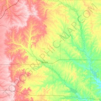
Nombre: Mapa topográfico Greenwood County, altitud, relieve.
Lugar: Greenwood County, Kansas, United States of America (37.60338 -96.52556 38.17407 -95.95884)
Altitud media: 372 m
Altitud mínima: 266 m
Altitud máxima: 507 m
Otros mapas topográficos
Haga clic en un mapa para ver su topografía, su altitud y su relieve.
Lawrence
United States of America > Kansas > Lawrence
Lawrence, Douglas County, Kansas, United States of America
Altitud media: 265 m
Pottawatomie County
United States of America > Kansas
Pottawatomie County, Kansas, United States of America
Altitud media: 367 m