
Mapa topográfico Mont de la Dives
Mapa interactivo
Haga clic en el mapa para ver la altitud.
Acerca de este mapa
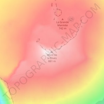
Nombre: Mapa topográfico Mont de la Dives, altitud, relieve.
Altitud media: 656 m
Altitud mínima: 95 m
Altitud máxima: 872 m
Otros mapas topográficos
Haga clic en un mapa para ver su topografía, su altitud y su relieve.
Juan de Nova Island
France > French Southern and Antarctic Lands
Juan de Nova Island, Scattered Islands in the Indian Ocean, French Southern and Antarctic Lands, France
Altitud media: 0 m
Port-aux-Français
France > French Southern and Antarctic Lands
Port-aux-Français, Kerguelen Archipelago, French Southern and Antarctic Lands, France
Altitud media: 14 m
Mount Calliope
France > French Southern and Antarctic Lands
Mount Calliope, Kerguelen Archipelago, French Southern and Antarctic Lands, France
Altitud media: 102 m
Possession Island
France > French Southern and Antarctic Lands
Possession Island, French Southern and Antarctic Lands, France
Altitud media: 13 m
Kerguelen Archipelago
France > French Southern and Antarctic Lands
Kerguelen Archipelago, French Southern and Antarctic Lands, France
Altitud media: 38 m
New Amsterdam Island
France > French Southern and Antarctic Lands
New Amsterdam Island, Saint Paul and New Amsterdam Islands, French Southern and Antarctic Lands, France
Altitud media: 6 m
Penguin Island
France > French Southern and Antarctic Lands
Penguin Island, French Southern and Antarctic Lands, France
Altitud media: 46 m