
Mapa topográfico Lake Coeur d'Alene
Mapa interactivo
Haga clic en el mapa para ver la altitud.
Lake Coeur d'Alene
The lake's elevation varies from 2,128 feet (649 m) above sea level in the summer to up to 7 feet (2.1 m) lower in the winter, controlled by the Post Falls Dam 9 miles (14 km) below the lake on the Spokane River.
Acerca de este mapa
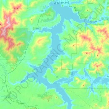
Nombre: Mapa topográfico Lake Coeur d'Alene, altitud, relieve.
Altitud media: 827 m
Altitud mínima: 640 m
Altitud máxima: 1 579 m