
Mapa topográfico Serre Chevalier
Mapa interactivo
Haga clic en el mapa para ver la altitud.
Acerca de este mapa
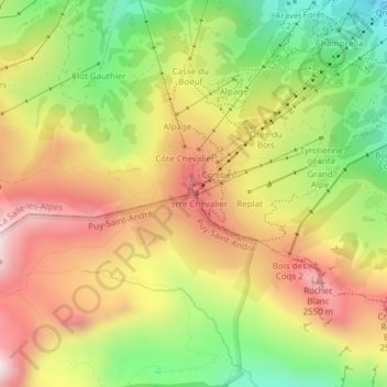
Nombre: Mapa topográfico Serre Chevalier, altitud, relieve.
Altitud media: 2 256 m
Altitud mínima: 1 905 m
Altitud máxima: 2 592 m
The maximum elevation for skiing is at Telesiege Yret at 2,800 m (9,190 ft) above sea level, and the minimum is 1,200 m (3,940 ft), a total vertical drop of 1,600 m (5,250 ft). One of the outstanding features of Serre Chevalier is the wooded nature of the slopes. The timber line is at 2,150 m (7,050 ft), yielding about 700 m (2,300 ft) of vertical drop of tree-lined slopes.