
Mapa topográfico Trenton
Mapa interactivo
Haga clic en el mapa para ver la altitud.
Acerca de este mapa
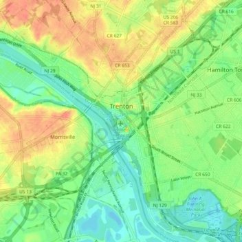
Nombre: Mapa topográfico Trenton, altitud, relieve.
Lugar: Trenton, Mercer County, New Jersey, United States (40.18383 -74.81958 40.24830 -74.72890)
Altitud media: 20 m
Altitud mínima: -1 m
Altitud máxima: 44 m
According to the Köppen climate classification, Trenton lies in the transition from a cooler humid continental climate (Dfa) and the warmer humid subtropical (Cfa), and precipitation fairly evenly distributed through the year. The Cfa climate is the result of adiabatic warming of the Appalachians, low altitude and proximity to the coast without being on the immediate edge for moderate temperatures.