
Mapa topográfico Alta
Mapa interactivo
Haga clic en el mapa para ver la altitud.
Acerca de este mapa
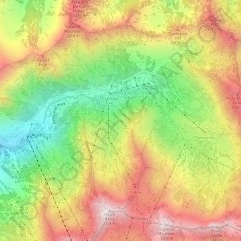
Nombre: Mapa topográfico Alta, altitud, relieve.
Lugar: Alta, Salt Lake County, Utah, United States (40.56441 -111.65273 40.60326 -111.59808)
Altitud media: 2 912 m
Altitud mínima: 2 437 m
Altitud máxima: 3 369 m
Alta experiences a high altitude humid continental climate (Köppen Dfb), which borders on a subalpine climate (Dfc), due to its high elevation. Due to its proximity to the Great Salt Lake, the town receives very heavy snows, averaging over 507 inches (12.9 m) per year. During the very wet season of 1982/1983, Alta received as much as 900 inches (23 m) of snow, leading to record flooding of Wasatch streams as the snow melted during May and June that year. Alta's total precipitation of 108.54 inches (2,756.9 mm) during 1983 is a record for a calendar year in any state of the Mountain West.
Otros mapas topográficos
Haga clic en un mapa para ver su topografía, su altitud y su relieve.
Magna
United States > Utah > Salt Lake County
Magna, Salt Lake County, Utah, United States
Altitud media: 1 341 m
Taylorsville
United States > Utah > Salt Lake County
Taylorsville, Salt Lake County, Utah, United States
Altitud media: 1 325 m
Draper
United States > Utah > Salt Lake County
Draper, Salt Lake County, Utah, 84020, United States
Altitud media: 1 573 m