
Mapa topográfico Penrith
Mapa interactivo
Haga clic en el mapa para ver la altitud.
Acerca de este mapa
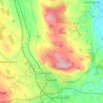
Nombre: Mapa topográfico Penrith, altitud, relieve.
Lugar: Penrith, Cumberland, England, United Kingdom (54.64616 -2.79696 54.72604 -2.70703)
Altitud media: 162 m
Altitud mínima: 76 m
Altitud máxima: 281 m
Otros mapas topográficos
Haga clic en un mapa para ver su topografía, su altitud y su relieve.
Winder Gate
United Kingdom > England > Cumberland > Frizington
Winder Gate, Arlecdon and Frizington, Frizington, Cumberland, England, CA26 3QS, United Kingdom
Altitud media: 139 m
Carlisle
United Kingdom > England > Cumberland
Carlisle, Cumberland, England, United Kingdom
Altitud media: 31 m
Legburthwaite
United Kingdom > England > Cumberland
Legburthwaite, Cumberland, England, CA12 4TQ, United Kingdom
Altitud media: 392 m
Braithwaite
United Kingdom > England > Cumberland
Braithwaite, Cumberland, England, CA12 5TJ, United Kingdom
Altitud media: 176 m
The Green
United Kingdom > England > Cumberland
The Green, Cumberland, England, LA18 5HL, United Kingdom
Altitud media: 64 m
Emerald Pools
United Kingdom > England > Cumberland
Emerald Pools, Wasdale, Cumberland, England, United Kingdom
Altitud media: 523 m
Bridgefoot
United Kingdom > England > Cumberland
Bridgefoot, Little Clifton, Cumberland, England, CA14 1XY, United Kingdom
Altitud media: 65 m
Drumburgh
United Kingdom > England > Cumberland
Drumburgh, Cumberland, England, CA7 5DP, United Kingdom
Altitud media: 6 m
Rottington
United Kingdom > England > Cumberland
Rottington, Cumberland, England, CA28 9UR, United Kingdom
Altitud media: 56 m