
Mapa topográfico Kalaw
Mapa interactivo
Haga clic en el mapa para ver la altitud.
Acerca de este mapa
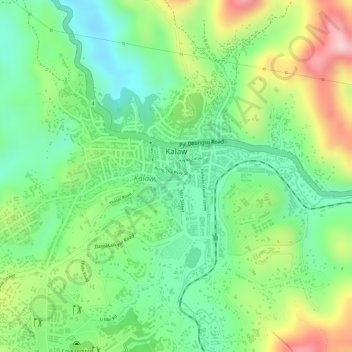
Nombre: Mapa topográfico Kalaw, altitud, relieve.
Altitud media: 1 348 m
Altitud mínima: 1 249 m
Altitud máxima: 1 498 m
The hill station is located at an elevation of 1310 metres, 50 km from the Inle lake. Kalaw is famous for hiking and trekking. Many trekking trails ranging from nearby places to Inle Lake and Pindaya. The town still feels like a high-altitude holiday resort – the air is cool, the atmosphere is calm and the tree-lined streets still contain a smattering of colonial-era architecture – while the surrounding hills are fine for relatively easy day or overnight treks to Danu, Danaw, Palaung, Pa-O and Taung Yo villages.