
Mapa topográfico Soreng
Mapa interactivo
Haga clic en el mapa para ver la altitud.
Acerca de este mapa
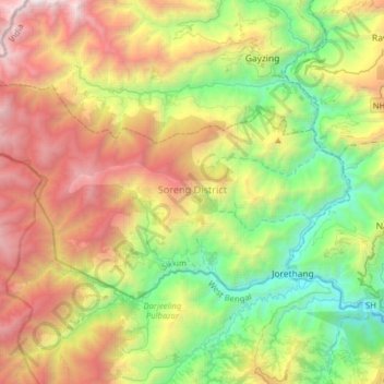
Nombre: Mapa topográfico Soreng, altitud, relieve.
Lugar: Soreng, Soreng District, Sikkim, India (27.11193 88.01203 27.27042 88.33039)
Altitud media: 1 620 m
Altitud mínima: 244 m
Altitud máxima: 3 751 m
Otros mapas topográficos
Haga clic en un mapa para ver su topografía, su altitud y su relieve.
Lachung
India > Sikkim > Chungthang
Lachung, Chungthang, North Sikkim District, Sikkim, India
Altitud media: 3 617 m
Katao
India > Sikkim > Chungthang
Katao, Chungthang, North Sikkim District, Sikkim, India
Altitud media: 4 505 m
East District
India > Sikkim > East District
East District, East Sikkim District, Sikkim, India
Altitud media: 2 740 m