
Mapa topográfico Thornley-with-Wheatley
Mapa interactivo
Haga clic en el mapa para ver la altitud.
Acerca de este mapa
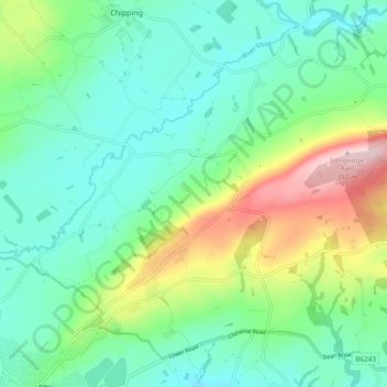
Nombre: Mapa topográfico Thornley-with-Wheatley, altitud, relieve.
Altitud media: 150 m
Altitud mínima: 75 m
Altitud máxima: 343 m
Otros mapas topográficos
Haga clic en un mapa para ver su topografía, su altitud y su relieve.
Sabden
Vereinigtes Königreich > England > Lancashire > Ribble Valley
Sabden, Ribble Valley, Lancashire, England, Vereinigtes Königreich
Altitud media: 236 m
Walker Fold
Vereinigtes Königreich > England > Lancashire > Ribble Valley
Walker Fold, Aighton, Bailey and Chaigley, Ribble Valley, Lancashire, England, BB7 3LU, Vereinigtes Königreich
Altitud media: 170 m