
Mapa topográfico Peoria Heights
Mapa interactivo
Haga clic en el mapa para ver la altitud.
Acerca de este mapa
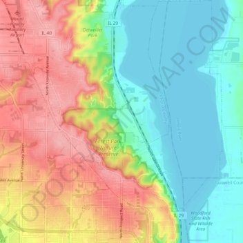
Nombre: Mapa topográfico Peoria Heights, altitud, relieve.
Altitud media: 182 m
Altitud mínima: 133 m
Altitud máxima: 251 m
Topographically, the village can be roughly divided into three zones. The Illinois River floodplain, the bluff, and the plateau. While its eastern border is fairly regular with the river's edge, the rest of its municipal border, with Peoria, is quite irregular and convoluted.