
Gracias por apoyar a este sitio ❤️
Haz una donación
Haz una donación
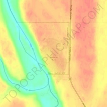
Mapa topográfico Meander River
Haga clic en el mapa para ver la altitud.
Gracias por apoyar a este sitio ❤️
Haz una donación
Haz una donación
Meander River
The settlement is located on the banks of the Hay River, at an elevation of 328 meters (1,076 ft). The plant hardiness zone of Meander River is 0B, the second lowest possible within Canada, due primarily to its northern latitude.
Gracias por apoyar a este sitio ❤️
Haz una donación
Haz una donación
Acerca de este mapa
Nombre: Mapa topográfico Meander River, altitud, relieve.
Lugar: Meander River, Mackenzie County, Alberta, Canada (59.03497 -117.72398 59.05497 -117.70398)
Altitud media: 325 m
Altitud mínima: 292 m
Altitud máxima: 341 m
Gracias por apoyar a este sitio ❤️
Haz una donación
Haz una donación