
Haz una donación
Mapa topográfico Neuenkleusheim
Haga clic en el mapa para ver la altitud.
Haz una donación
Neuenkleusheim
Kleusheim liegt westlich der Wasserscheide von Bigge-Sieg bzw. Bigge-Lenne. Dieser Höhenzug war bis 1814 zugleich Landesgrenze des Herzogtums Westfalen gegenüber Nassau-Siegen. Diese Grenze, das „Kölsche-Heck“, bildete somit eine Landes-, Religions- und Sprachgrenze. Die Bigge-Lenne-Wasserscheide trennt im Weiteren das Kirchspiel Kleusheim von der Pfarrei Rahrbach. Jedes der drei Dörfer liegt in einem eigenen Tal. Altenkleusheim wird von Neuenkleusheim durch einen Höhenzug, gebildet aus Stübelhagen (499 m), Eichhagen und Hohenhagen (482 m), getrennt. Rehringhausen liegt weiter nördlich und wird von Neuenkleusheim durch den Kruberg (505 m), Engelsberg (588 m) und Hesselberg getrennt. Geografisch liegt Kleusheim im Olper Hügelland das geologisch den Devonformationen angehört.
Haz una donación
Acerca de este mapa
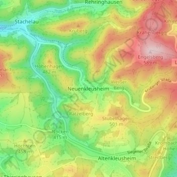
Nombre: Mapa topográfico Neuenkleusheim, altitud, relieve.
Altitud media: 447 m
Altitud mínima: 335 m
Altitud máxima: 583 m
Haz una donación
Otros mapas topográficos
Haga clic en un mapa para ver su topografía, su altitud y su relieve.