
Mapa topográfico Vanderbijlpark
Mapa interactivo
Haga clic en el mapa para ver la altitud.
Acerca de este mapa
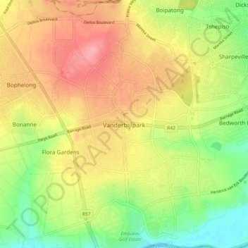
Nombre: Mapa topográfico Vanderbijlpark, altitud, relieve.
Altitud media: 1 474 m
Altitud mínima: 1 421 m
Altitud máxima: 1 525 m
Vanderbijlpark is situated on the highveld of South Africa, at an altitude of 1,500 meters on the banks of the Vaal River. Summers in the city are warm to hot with an average high between 31 and 35°C, and an average low between 15 and 22°C. Winters in the city are cool to warm with an average high of between 18 and 23°C and an average low of between −1 and 5°C.
Otros mapas topográficos
Haga clic en un mapa para ver su topografía, su altitud y su relieve.
Evaton
South Africa > Gauteng > Sedibeng District Municipality > Emfuleni Local Municipality
Evaton, Emfuleni Local Municipality, Sedibeng District Municipality, Gauteng, South Africa
Altitud media: 1 522 m
Sebokeng
South Africa > Gauteng > Sedibeng District Municipality > Emfuleni Local Municipality
Sebokeng, Emfuleni Local Municipality, Sedibeng District Municipality, Gauteng, 1984, South Africa
Altitud media: 1 523 m