
Haz una donación
Mapa topográfico Jabal Shams
Haga clic en el mapa para ver la altitud.
Haz una donación
Jabal Shams
The mountain also has a second summit, the South Summit, which is publicly accessible for trekking via the W4 Trail, marked by the Oman Ministry of Tourism. The elevation of the second south summit is 2,997 m (9,833 ft).
Haz una donación
Acerca de este mapa
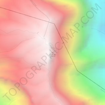
Nombre: Mapa topográfico Jabal Shams, altitud, relieve.
Altitud media: 2 451 m
Altitud mínima: 1 379 m
Altitud máxima: 2 985 m
Haz una donación
Otros mapas topográficos
Haga clic en un mapa para ver su topografía, su altitud y su relieve.
Izki
Oman > Ad Dakhiliyah Governorate
Izki (Arabic: إِزْكِي) is a town in the Ad Dakhiliyah region of northeastern Oman. It is located at c. 544 m (1,785 ft) altitude, and has a population of 35,173 (2003 census).
Altitud media: 662 m
Bahla Fort
Oman > Ad Dakhiliyah Governorate > Bahla Province
Preservation attempt in 1995 was found to be a renovation not a restoration because the aim of the remodeling was to make the fort look new. This renovation began without prior archaeological, topographic, architectural or technical surveys.
Altitud media: 575 m
Haz una donación