
Mapa topográfico Sequoia National Park
Mapa interactivo
Haga clic en el mapa para ver la altitud.
Acerca de este mapa
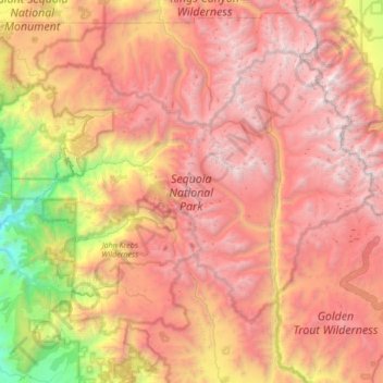
Nombre: Mapa topográfico Sequoia National Park, altitud, relieve.
Altitud media: 2 515 m
Altitud mínima: 265 m
Altitud máxima: 4 401 m
Many park visitors enter Sequoia National Park through its southern entrance near the town of Three Rivers at Ash Mountain at 1,700 ft (520 m) elevation. The lower elevations around Ash Mountain contain the only National Park Service-protected California Foothills ecosystem, consisting of blue oak woodlands, foothills chaparral, grasslands, yucca plants, and steep, mild river valleys. Seasonal weather results in a changing landscape throughout the foothills with hot summer yielding an arid landscape while spring and winter rains result in blossoming wildflowers and lush greens. The region is also home to abundant wildlife: bobcats, foxes, ground squirrels, rattlesnakes, and mule deer are commonly seen in this area, and more rarely, reclusive mountain lions and the Pacific fisher are seen as well. The last California grizzly was killed in this park in 1922 (at Horse Corral Meadow). The California Black Oak is a key transition species between the chaparral and higher elevation conifer forest.
Otros mapas topográficos
Haga clic en un mapa para ver su topografía, su altitud y su relieve.
Visalia
United States > California > Tulare County
Visalia, Tulare County, California, United States
Altitud media: 102 m
Moro Rock
United States > California > Tulare County
Moro Rock, Tulare County, California, United States
Altitud media: 1 628 m
Three Rivers
United States > California > Tulare County
Three Rivers, Tulare County, California, United States
Altitud media: 661 m
Mount Ericsson
United States > California > Tulare County
Mount Ericsson, Tulare County, California, United States
Altitud media: 3 707 m