
Mapa topográfico Brunswick
Mapa interactivo
Haga clic en el mapa para ver la altitud.
Acerca de este mapa
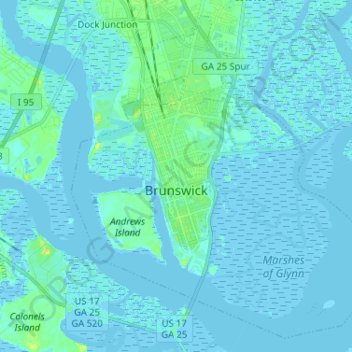
Nombre: Mapa topográfico Brunswick, altitud, relieve.
Lugar: Brunswick, Glynn County, Georgia, United States (31.10341 -81.53020 31.20499 -81.40078)
Altitud media: 2 m
Altitud mínima: -3 m
Altitud máxima: 22 m
The city is the lowest in the U.S. state of Georgia, with an elevation of only 10 to 14 feet (3.0 to 4.3 m) above sea level. According to the U.S. Census Bureau, Brunswick's land area is 32.4 square miles (83.8 km2). Its total area is 42.4 square miles (109.8 km2); 10.0 square miles (26.0 km2) of this is water.
Otros mapas topográficos
Haga clic en un mapa para ver su topografía, su altitud y su relieve.
Saint Simons Island
United States > Georgia > Glynn County
Saint Simons Island, Glynn County, Georgia, 31561, United States
Altitud media: 2 m
Jointer Island
United States > Georgia > Glynn County > Brunswick
Jointer Island, Brunswick, Glynn County, Georgia, United States
Altitud media: 0 m
Fancy Bluff
United States > Georgia > Glynn County
Fancy Bluff, Glynn County, Georgia, United States
Altitud media: 3 m
Saint Simon Mills
United States > Georgia > Glynn County
Saint Simon Mills, Glynn County, Georgia, 31522, United States
Altitud media: 3 m
Saint Simons
United States > Georgia > Glynn County
Saint Simons, Glynn County, Georgia, 31522, United States
Altitud media: 2 m
Jekyll Island
United States > Georgia > Glynn County > Saint Simons
Jekyll Island, Saint Simons, Glynn County, Georgia, 31527, United States
Altitud media: 1 m
Gordon Oaks Homes
United States > Georgia > Glynn County > Brunswick
Gordon Oaks Homes, Brunswick, Glynn County, Georgia, 32523, United States
Altitud media: 3 m
Riverside
United States > Georgia > Glynn County > Brunswick > Riverside
Riverside, Brunswick, Glynn County, Georgia, 31520, United States
Altitud media: 3 m