
Mapa topográfico Chittenden County
Mapa interactivo
Haga clic en el mapa para ver la altitud.
Acerca de este mapa
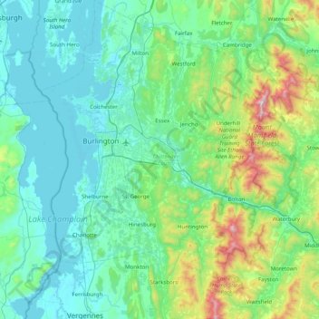
Nombre: Mapa topográfico Chittenden County, altitud, relieve.
Lugar: Chittenden County, Vermont, United States of America (44.16141 -73.36204 44.72281 -72.80238)
Altitud media: 228 m
Altitud mínima: 25 m
Altitud máxima: 1 305 m
The town of Underhill in Chittenden County is home to the highest summit within the state, Mount Mansfield, which has a peak elevation of 4,393 feet (1,339 m) above sea level.
Otros mapas topográficos
Haga clic en un mapa para ver su topografía, su altitud y su relieve.
Rutland County
United States of America > Vermont
Rutland County, Vermont, United States of America
Altitud media: 363 m
Burlington
United States of America > Vermont > Burlington
Burlington, Chittenden County, Vermont, United States of America
Altitud media: 58 m