
Gracias por apoyar a este sitio ❤️
Haz una donación
Haz una donación
Mapa topográfico Lewis Pass
Haga clic en el mapa para ver la altitud.
Gracias por apoyar a este sitio ❤️
Haz una donación
Haz una donación
Lewis Pass
Lewis Pass is the northernmost of the three main mountain passes through the Southern Alps in the South Island of New Zealand. With an elevation of 907 metres, it is slightly lower than Arthur's Pass and higher than Haast Pass.
Gracias por apoyar a este sitio ❤️
Haz una donación
Haz una donación
Acerca de este mapa
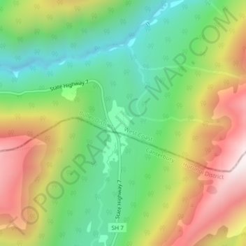
Nombre: Mapa topográfico Lewis Pass, altitud, relieve.
Lugar: Lewis Pass, Buller District, West Coast, New Zealand (-42.37855 172.40098 -42.37845 172.40108)
Altitud media: 1 039 m
Altitud mínima: 680 m
Altitud máxima: 1 547 m
Gracias por apoyar a este sitio ❤️
Haz una donación
Haz una donación
Otros mapas topográficos
Haga clic en un mapa para ver su topografía, su altitud y su relieve.
Gracias por apoyar a este sitio ❤️
Haz una donación
Haz una donación
Gracias por apoyar a este sitio ❤️
Haz una donación
Haz una donación
Buller River Mouth Wildlife Refuge
New Zealand > West Coast > Buller District > Westport
Altitud media: 5 m
Gracias por apoyar a este sitio ❤️
Haz una donación
Haz una donación