
Mapa topográfico Tackaberry Lake
Mapa interactivo
Haga clic en el mapa para ver la altitud.
Acerca de este mapa
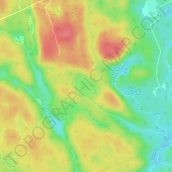
Nombre: Mapa topográfico Tackaberry Lake, altitud, relieve.
Altitud media: 338 m
Altitud mínima: 304 m
Altitud máxima: 370 m
Otros mapas topográficos
Haga clic en un mapa para ver su topografía, su altitud y su relieve.
Limberlost Forest and Wildlife Reserve
Canada > Ontario > Muskoka District > Lake of Bays Township
Limberlost Forest and Wildlife Reserve, Lake of Bays Township, District Municipality of Muskoka, Muskoka District, Central Ontario, Ontario, Canada
Altitud media: 400 m
Dwight
Canada > Ontario > Muskoka District > Lake of Bays Township
Dwight, Lake of Bays Township, District Municipality of Muskoka, Muskoka District, Central Ontario, Ontario, Canada
Altitud media: 341 m