
Mapa topográfico Coeur d'Alene
Mapa interactivo
Haga clic en el mapa para ver la altitud.
Acerca de este mapa
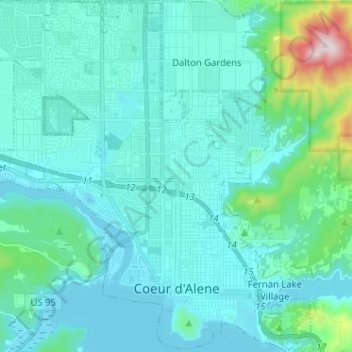
Nombre: Mapa topográfico Coeur d'Alene, altitud, relieve.
Altitud media: 719 m
Altitud mínima: 644 m
Altitud máxima: 1 254 m
The city is located on the north shore of Lake Coeur d'Alene, near the outlet of the Spokane River, and is in the Northern Rockies ecoregion. Lake Coeur d'Alene is a natural dam-controlled lake that is 25 miles (40 km) long and 1 mile (1.6 km) to 3 miles (4.8 km) wide and fed by the Coeur d'Alene and Saint Joe rivers. Although the Post Falls Dam on the Spokane River near Post Falls controls the lake levels, the lake is usually kept at natural levels from January to June. To the immediate southeast is Fernan Lake and to the northeast of the city is Hayden Lake and even further northeast in northern Kootenai County is Lake Pend Oreille, which is among the largest and deepest natural lakes in the western United States with a surface area of 85,960 acres (347.9 km2) and maximum depth of 1,152 feet (351 m). These lakes, like others in the Spokane Valley and Rathdrum Prairie, were formed by the Missoula Floods, which ended 12,000 to 15,000 years ago. The Coeur d'Alene Mountains of the Bitterroot Range rise to the east of the city to a maximum elevation of 7,352 feet (2,241 m) at Cherry Peak.
Otros mapas topográficos
Haga clic en un mapa para ver su topografía, su altitud y su relieve.
Post Falls
United States > Idaho > Kootenai County
Post Falls, Kootenai County, Idaho, 83854, United States
Altitud media: 710 m
Hauser
United States > Idaho > Kootenai County
Hauser, Kootenai County, Idaho, United States
Altitud media: 712 m
Bayview
United States > Idaho > Kootenai County
Bayview, Kootenai County, Idaho, United States
Altitud media: 733 m
Farragut State Park
United States > Idaho > Kootenai County > Bayview
Farragut State Park, Bayview, Kootenai County, Idaho, United States
Altitud media: 723 m
Fernan Saddle
United States > Idaho > Kootenai County
Fernan Saddle, Kootenai County, Idaho, United States
Altitud media: 1 201 m
Lake Coeur d'Alene
United States > Idaho > Kootenai County > Harrison
Lake Coeur d'Alene, Harrison, Kootenai County, Idaho, United States
Altitud media: 827 m
Hayden
United States > Idaho > Kootenai County
Hayden, Kootenai County, Idaho, United States
Altitud media: 709 m
Fernan Lake
United States > Idaho > Kootenai County > Coeur d'Alene
Fernan Lake, Coeur d'Alene, Kootenai County, Idaho, United States
Altitud media: 743 m
Athol
United States > Idaho > Kootenai County
Athol, Kootenai County, Idaho, United States
Altitud media: 733 m
Cataldo
United States > Idaho > Kootenai County
Cataldo, Kootenai County, Idaho, 83839, United States
Altitud media: 732 m
Bellgrove
United States > Idaho > Kootenai County
Bellgrove, Kootenai County, Idaho, United States
Altitud media: 802 m
Silver Sands Beach
United States > Idaho > Kootenai County
Silver Sands Beach, Kootenai County, Idaho, United States
Altitud media: 766 m
Hauser Lake
United States > Idaho > Kootenai County > Hauser
Hauser Lake, Hauser, Kootenai County, Idaho, United States
Altitud media: 696 m
Hayden
United States > Idaho > Kootenai County
Hayden, Kootenai County, Idaho, 83835, United States
Altitud media: 717 m
Cherry Hill
United States > Idaho > Kootenai County > Coeur d'Alene
Cherry Hill, Coeur d'Alene, Kootenai County, Idaho, 83815, United States
Altitud media: 708 m
Dalton Gardens
United States > Idaho > Kootenai County
Dalton Gardens, Kootenai County, Idaho, United States
Altitud media: 697 m
Rathdrum
United States > Idaho > Kootenai County
Rathdrum, Kootenai County, Idaho, United States
Altitud media: 701 m
Spirit Lake
United States > Idaho > Kootenai County
Spirit Lake, Kootenai County, Idaho, 83869, United States
Altitud media: 780 m
Harrison
United States > Idaho > Kootenai County
Harrison, Kootenai County, Idaho, United States
Altitud media: 745 m
Worley
United States > Idaho > Kootenai County
Worley, Kootenai County, Idaho, United States
Altitud media: 830 m