
Mapa topográfico Taos County
Mapa interactivo
Haga clic en el mapa para ver la altitud.
Acerca de este mapa
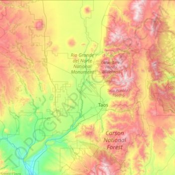
Nombre: Mapa topográfico Taos County, altitud, relieve.
Lugar: Taos County, New Mexico, United States of America (36.01287 -106.05840 36.99597 -105.20011)
Altitud media: 2 561 m
Altitud mínima: 1 709 m
Altitud máxima: 3 980 m
The county's highest point is the summit of Wheeler Peak at 13,161 feet (4,011 m). This is also the highest natural point in New Mexico. The county has the highest mean elevation of any U.S. county outside of Colorado at 8,510 feet (2,590 m), even though it ranks only 22nd overall. Taos County contains 17 of New Mexico's highest 25 peaks.
Otros mapas topográficos
Haga clic en un mapa para ver su topografía, su altitud y su relieve.
Doña Ana County
United States of America > New Mexico
Doña Ana County, New Mexico, United States of America
Altitud media: 1 349 m
Santa Fe County
United States of America > New Mexico
Santa Fe County, New Mexico, United States of America
Altitud media: 2 177 m
Torrance County
United States of America > New Mexico
Torrance County, New Mexico, United States of America
Altitud media: 1 983 m