
Mapa topográfico Torrance County
Mapa interactivo
Haga clic en el mapa para ver la altitud.
Acerca de este mapa
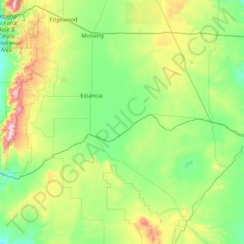
Nombre: Mapa topográfico Torrance County, altitud, relieve.
Lugar: Torrance County, New Mexico, United States of America (34.25968 -106.47122 35.04214 -105.29014)
Altitud media: 1 983 m
Altitud mínima: 1 725 m
Altitud máxima: 3 035 m
According to the U.S. Census Bureau, the county has a total area of 3,346 square miles (8,670 km2), of which 3,345 square miles (8,660 km2) is land and 0.9 square miles (2.3 km2) (0.03%) is water. Most of the county is gently-rolling grassland ranging from 6000 to 6200 feet in elevation. The Manzano Mountains rising to 10,098 feet on the western edge of the county provide it with its only significant topographic relief. The Manzano Wilderness area includes the highest part of the mountains. The other notable geographic feature of the county is the series of playas and seasonal lakes centering on Laguna del Perro southeast of Estancia.
Otros mapas topográficos
Haga clic en un mapa para ver su topografía, su altitud y su relieve.
Doña Ana County
United States of America > New Mexico
Doña Ana County, New Mexico, United States of America
Altitud media: 1 349 m
Santa Fe County
United States of America > New Mexico
Santa Fe County, New Mexico, United States of America
Altitud media: 2 177 m
Taos County
United States of America > New Mexico
Taos County, New Mexico, United States of America
Altitud media: 2 561 m