
Mapa topográfico LeConte Glacier
Mapa interactivo
Haga clic en el mapa para ver la altitud.
Acerca de este mapa
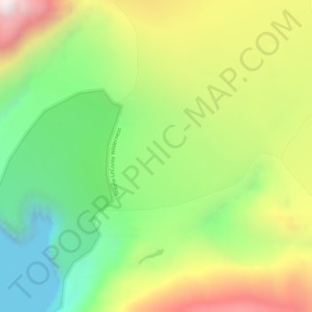
Nombre: Mapa topográfico LeConte Glacier, altitud, relieve.
Lugar: LeConte Glacier, Petersburg Borough, Alaska, USA (56.83635 -132.35081 56.83645 -132.35071)
Altitud media: 407 m
Altitud mínima: 0 m
Altitud máxima: 968 m
Otros mapas topográficos
Haga clic en un mapa para ver su topografía, su altitud y su relieve.
Glacier Bay National Park
Glacier Bay National Park, Hoonah-Angoon, Alaska, USA
Altitud media: 556 m
Tanana River
USA > Alaska > Manley Hot Springs
Tanana River, Manley Hot Springs Road, Manley Hot Springs, Unorganized Borough, Alaska, 99756, USA
Altitud media: 320 m
Lake Clark National Park and Preserve
Lake Clark National Park and Preserve, Kenai Peninsula, Alaska, USA
Altitud media: 673 m
Anaktuvuk Pass
USA > Alaska > Anaktuvuk Pass
Anaktuvuk Pass, North Slope, Alaska, 99721, USA
Altitud media: 743 m
Matanuska Glacier
Matanuska Glacier, Matanuska-Susitna, Alaska, USA
Altitud media: 1 819 m
Chugach State Park at Cooper Landing
USA > Alaska > Cooper Landing
Chugach State Park at Cooper Landing, Cooper Landing, Kenai Peninsula, Alaska, USA
Altitud media: 234 m
Princeton Glacier
Princeton Glacier, Unorganized Borough, Alaska, USA
Altitud media: 621 m
Chuginadak Island
Chuginadak Island, Unorganized Borough, Alaska, USA
Altitud media: 102 m
Gates of the Arctic
Gates of the Arctic, Unorganized Borough, Alaska, USA
Altitud media: 665 m
Kobuk Valley National Park
Kobuk Valley National Park, Northwest Arctic, Alaska, USA
Altitud media: 331 m