
Mapa topográfico Cooking Lake
Mapa interactivo
Haga clic en el mapa para ver la altitud.
Acerca de este mapa
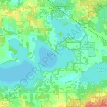
Nombre: Mapa topográfico Cooking Lake, altitud, relieve.
Lugar: Cooking Lake, Strathcona County, Alberta, Canada (53.39853 -113.13058 53.47187 -112.94798)
Altitud media: 745 m
Altitud mínima: 732 m
Altitud máxima: 790 m
Otros mapas topográficos
Haga clic en un mapa para ver su topografía, su altitud y su relieve.
Hamlet of Antler Lake
Canada > Alberta > Strathcona County
Hamlet of Antler Lake, Strathcona County, Alberta, Canada
Altitud media: 745 m
Hastings Lake
Canada > Alberta > Strathcona County
Hastings Lake, Strathcona County, Alberta, Canada
Altitud media: 744 m
Hamlet of Josephburg
Canada > Alberta > Strathcona County > Hamlet of Josephburg
Hamlet of Josephburg, Strathcona County, Alberta, T8L 4B8, Canada
Altitud media: 639 m
Ardrossan
Canada > Alberta > Strathcona County
Ardrossan, Strathcona County, Alberta, T8E 2A2, Canada
Altitud media: 710 m